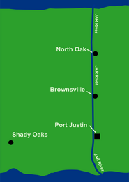
The JAR River in Jill.
The Jar River is a major waterway in Jill. The source of the Jar is the Monterry Sea on the northern coastline, and the end is the Jar River Delta approximately 2,113 miles to the south.
History and geology[]
The Jar River, along with most of the northern coast of Jill, had been documented by explorers from various nations for hundreds of years. When Jill was thoroughly explored and founded in 1837, settlers followed the Jar directly south to Port Justin, Jill's first settlement and modern-day capitol. The Jar is considered the most important geographical feature of Jill, since it has shaped the territory so dramatically and is the backbone of the nation's three largest cities.
Overview[]
The Jar River is estimated to be 2,113 miles long, and cuts through deserts and swamps. It begins at the city of North Port and ends at the South Sea at the extensive Jar River Delta.
See Also[]
- Port Justin, the largest city on the JAR River.
- Jill
| Jill |
| Major cities: Port Justin · Shady Oaks · Brownville · North Oak Geographical Features: JAR River · Shady Oaks River · Pine Mountain Other: Jill economy scare of 1972 |